Why go
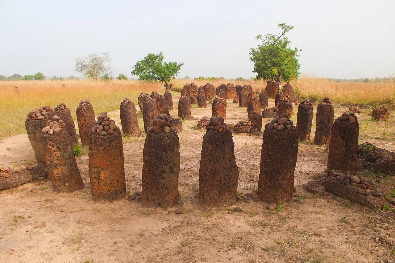
Wassu and Kerbatch are the Gambian half of the Stone Circles of Senegambia, a transnational site that UNESCO inscribed in 20061 under criteria i and iii. Together with two further groups across the border in Senegal, Sine Ngayène and Wanar, the four sites hold 93 stone circles and count among more than 1,000 monuments scattered along roughly 350 km of the Gambia River2. Nothing else in West Africa concentrates this much prehistoric megalithic building in one river valley.
The circles are burial markers, not temples or calendars. Excavation shows burials happened first, with the laterite pillars raised afterwards over the graves, a sequence that points to a settled, prosperous society able to organise large building projects over many generations. The builders worked across an extraordinary span of time: the earliest stones in the wider Senegambian group date to the 3rd century BCE, the latest to the 16th century CE, and radiocarbon testing of burial mounds at Wassu itself narrows that site’s main use to AD 927 to 13052.
What you will see
Wassu is the larger and better-known of the two Gambian sites, with 11 separate stone circles. Each circle typically gathers 10 to 20 upright stones in a ring 4 to 6 metres across3, cut as identical cylindrical or polygonal pillars averaging about 2 metres tall and 7 tonnes in weight, all hacked from nearby laterite quarries with iron tools2. One monolith at Wassu stands 2.59 metres high4, reportedly the tallest recorded anywhere across the Senegambian sites. A small site museum displays what archaeologists recovered from the graves: cooking pots, spearheads, swords and bracelets5 buried alongside the dead.
Kerbatch (also spelled Kerr Batch), the second Gambian group, is smaller and quieter, with 9 circles plus one double circle2. Its best-known feature is a pair of stones set close together in a V shape, known locally as the lyre stone4, one of the “frontal stone” arrangements found at several of the Senegambian sites. Kerbatch sees far fewer visitors than Wassu, so the circles stand largely as they were found, with no crowds to work around.
Visiting
Neither site publishes official opening hours, and the facts box above shows only what is verified: the UNESCO listing itself. A Gambia-based travel blog that visited in 2025 reported 200 dalasi admission at Wassu, covering the circles, the museum and a guided tour, and 100 dalasi at Kerbatch; treat these as a guide rather than a guarantee, since both sites are run by the National Centre for Arts and Culture5 and prices can change without an online announcement. At Wassu, volunteer guides work the site for tips rather than a fixed fee, with 50 to 100 dalasi4 a reasonable amount; at Kerbatch, a resident Fula caretaker shows visitors around instead. Bring small-denomination dalasi, since neither site has a card machine or an ATM nearby.
Getting there
Both sites sit upcountry on the north bank of the Gambia River, reached most easily from Janjanbureh. The standard route starts with the ferry across to the north bank, which costs 10 dalasi, then a bush taxi from Lamin Koto to Wassu for around 30 dalasi, a journey of about an hour each way4. From Banjul and the coast resorts, most visitors book a tour rather than travel independently, since the drive upcountry runs around five hours3 each way.
Kerbatch is harder to reach on your own. It lies on the north-bank road between Farafenni and Janjanbureh, not served by public transport; getting there means hiring a tourist taxi for around 2,000 to 3,000 dalasi or walking the final 8 km4 from the highway. Visitors who want both sites in one trip typically rent a car or driver for two to three days and combine them with the river towns along the way; the getting around guide has the wider transport picture, including fares for bush taxis and vehicle hire.
Nearby
Janjanbureh Island, the old colonial river town, is the natural base for a visit: most travellers cross by the ferry at Lamin Koto on their way to Wassu, and the island’s own heritage walks and river tours fill out a two- or three-day trip upcountry. Further along the north-bank road towards Farafenni, the Senegambia Bridge gives a faster road route back to the coast than the old vehicle ferries. For the rest of the Gambia’s megaliths and river-town sights, the things to do guide and the Gambia country guide cover the wider picture.